 Frustrated by low-quality aerial photography on the free web-based mapping services (like Google Maps and TerraServer), I set out to find free sources of the USGS data itself. It comes from a government agency, so it should be simple for us taxpayers to find, right?
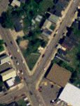
After much searching, I found some great resources at Michigan's Center for Geographic Information and the Michigan DNR Aerial Imagery Archive. A relatively complete listing of resources for other states can be found at lgalvin's site.
To use the Michigan CGI data, here's what I did:
- Select a county from the County Geographic Extent page.
- On the next page, select the aerial imagery you want to use. For Houghton county, I wanted the Digital Orthophoto Quads - 2005 series.
- Select and download a quadrangle. These are typically compressed in standard zip format.
- Unpack the file using the
unzipcommand (this works even though the files are self-extracting Windows executables). - Download and install FWTools for Linux.
- Convert the file to TIFF by running something like:
gdal_translate LAURIUM_NW.ecw LAURIUM_NW.tiff
For the Michigan DNR data, I did this:
- Select the 1998 series data from the Aerial Imagery Archive page.
- Select a county of interest, and then a quadrangle.
- Click on the map of the quadrangle to download the compressed image file.
- Download and unpack MrSID Decode for Linux.
- Convert the file to TIFF:
mrsidgeodecode_linux -i laurium_nw.sid -o laurium_nw.tiff
Either way, you'll now have a high-resolution TIFF that can be used in any number of image manipulation programs. I found the CGI imagery to be the most detailed, and far better than web-based mapping services.
 Rumors are flying that DCS wants to outsource email. Back in 2000, they outsourced our local Usenet groups, which was less than successful. James reminded me of my shenanigans back then:

